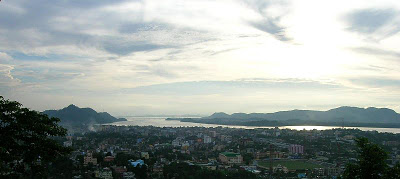
Gateway to North-East: Guwahati City

Today, the city straddles between the LGB International Airport in the west to Narengi in the east for almost 45 kilometres and between the southern bank of the Brahmaputra river and the foothills of the Shillong plateau for around 15 kilometres. Moreover, the city is also getting gradually expanded to the northern bank of Brahmaputra. Guwahati with population just 0.2 million in 1971 is a million plus city today. Guwahati Municipal Corporation (GMC), the city’s local government covers an area of 216 km², while Guwahati Metropolitan Development Authority (GMDA), the planning and development authority covers an area of 340 km².
It is a major commercial and educational center of eastern India and is home to world class institutions such as the Indian Institute of Technology Guwahati. The city is also a major center for cultural activities and sports in the North Eastern Region and for the administrative and political activities in Assam. The city is also an important hub for transportation in the North East Region.
Guwahati is also one of the most beautiful cities in South Asia with the mighty and picturesque Brahmaputra, river islands (e.g. Umananda), beaches, beach-islands (balicapori), thick tropical green cover, natural sweetwater lakes, hills with thick forests and with beautiful and lively native population.
Traditionally, Guwahati has been an important administrative and trading center and a river port. The name Guwahati is derived from two Assamese words: ‘guwa’ (areca nut) and ‘haat’ (market place). The name used to be spelled as Gowhatty (pre-colonial and colonial), standardized to Gauhati (colonial-British), which was then changed to the present form in the late 1980s to conform to the local pronunciation. Wiki

No place can be as heavenly than our own Assam